An evidence-based geospatial decision-support system that identifies critical healthcare gaps for rural elderly populations across Zambia, enabling data driven resource allocation and facility planning.
While national health statistics suggested adequate healthcare coverage, they masked a brutal reality: elderly rural residents faced prohibitive distances to reach appropriate care. Traditional district level health data couldn't reveal these hidden accessibility crises, leaving Ministry of Health planners blind to where need was greatest.
Resource allocation decisions were made without spatial precision, resulting in inefficient infrastructure investment and persistent healthcare inequities across Zambia's diverse rural landscape.
I designed and deployed SMILE-ZA, a sophisticated yet practical geospatial decision support system that pinpoints exactly where elderly populations lack access to healthcare infrastructure, enabling evidence-based resource allocation at sub-administrative scales.
Fishnet-grid methodology comparing elderly population density against healthcare facility availability across 100-meter cells, revealing micro scale disparities invisible in administrative aggregations.
HIGH (critical priority), MEDIUM (strained capacity), LOW (adequately served) classifications translating complex spatial relationships into actionable zones.
ArcGIS Dashboard translating technical spatial analysis into policy-relevant visualizations accessible to non GIS specialists, no specialized training required.
WMS, WFS, and CSW web services ensuring seamless integration with Zambia's National Spatial Data Infrastructure, pure interoperability, zero vendor lock-in.
Built entirely on open-source tools and freely available data, no licensing costs, no recurrent expenditure required for national scale deployment.
Extensible SDI foundation supporting future expansion to maternal health, disease surveillance, pharmaceutical distribution, or neighboring countries.
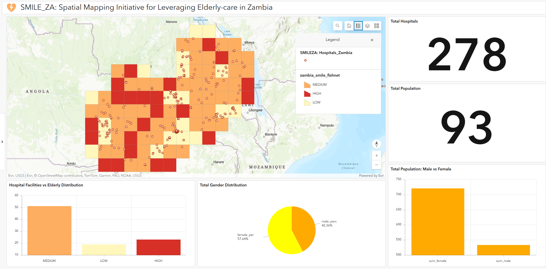
Live ArcGIS Dashboard: Interactive map visualization showing elderly population distribution (100m grid), hospital facility locations, and three tier priority classifications (HIGH/MEDIUM/LOW mismatch) across Zambia. The dashboard provides real-time summary statistics, facility counts, and demographic breakdowns enabling Ministry of Health decision making.
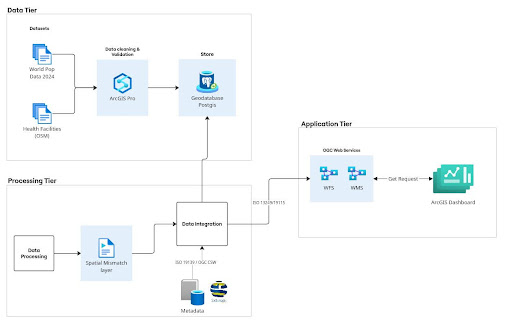
The system is built on a four layer Spatial Data Infrastructure (SDI) architecture designed for sustainability, interoperability, and scalability.
PostGIS enabled PostgreSQL database serving as authoritative spatial repository for vector geometries and raster datasets with spatial indexing for query optimization.
ArcGIS Pro for data preprocessing, spatial modeling, fishnet creation, and mismatch classification with Python scripting for automation and batch operations.
GeoServer exposing OGC-compliant WMS/WFS services; GeoNetwork managing ISO 19139 metadata via CSW protocol for dataset discovery and documentation.
ArcGIS Dashboard consuming WMS/WFS services, providing intuitive, policy relevant visualizations for Ministry of Health decision-makers.
SMILE-ZA System Architecture diagram showing the four layer SDI architecture with data storage, analytical processing, service publication, and user interface layers
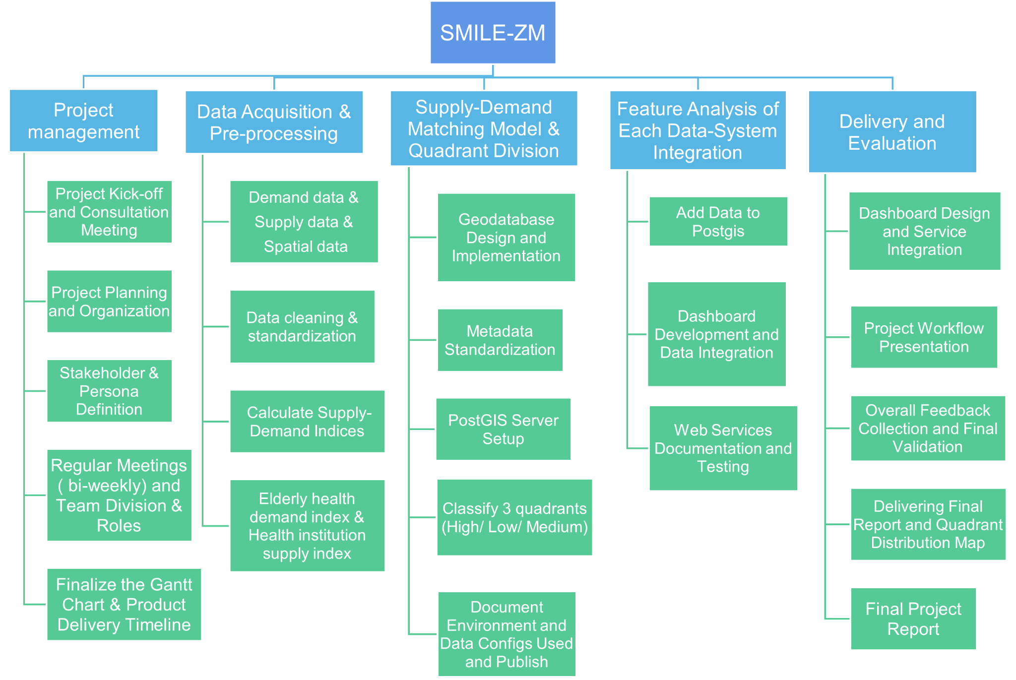
Comprehensive project workflow across five work packages (WP1-WP5) showing the sequential dependencies and critical path from project initialization through data acquisition, supply-demand modeling, spatial analysis, dashboard development, and final policy integration.
Formal project kick-off and stakeholder alignment with Ministry of Health
WorldPop elderly population raster and OSM health facility data cleaned, validated, and harmonized to WGS 84
Data quality validation and milestone checkpoint
Fishnet grid creation, zonal statistics extraction, supply-demand modeling, three-tier priority classification
Interactive ArcGIS Dashboard deployed; user acceptance testing with Ministry of Health personnel
Final dashboard optimization, policy brief generation, ministry strategy endorsement meeting and v1.0 release
Export district-level statistics showing elderly population counts and facility gaps to support funding requests for new health posts with precise spatial evidence.
Identify HIGH mismatch grids lacking permanent facilities to prioritize mobile health service deployment where it saves lives most.
Track changes in mismatch classifications over time as new facilities are established or population distributions shift—measuring progress toward healthcare equity.
Compare service coverage metrics across provinces to identify systemic inequalities requiring policy intervention at national level.
OGC-compliant architecture enables coordination with rural transportation networks, pension schemes, and NGO programs for holistic elderly care solutions.
High-resolution (100-meter) gridded population estimates for the 60+ age group across Zambia, enabling fine-scale analysis of elderly healthcare needs at sub-administrative scales. Updated annually and freely available for research use.
Crowd-sourced point locations of hospitals and healthcare facilities in Zambia, cleaned and validated to remove duplicates and spatial errors. Provides the most comprehensive national-scale facility dataset available without licensing restrictions.
Interact with the live system, a hypothetical scenario for Zambia's Ministry of Health, useful for identifying priority areas for elderly care infrastructure investment and resource allocation.